 عربي
عربي
H.E. Dr. Awad, highlights the Forty Four Annual Commemoration of Land Day in Statistical Figures
On the eve of the Forty Four annual commemoration of Land Day, on 30/03/2020, H.E. Dr. Ola Awad, President of the Palestinian Central Bureau of Statistics "PCBS", highlighted the Land Day in statistical figures, as follows:
The Palestinian people remember the Annual Commemoration of Land Day. The day in which the Israeli occupation laid hand over and confiscated 21 thousand dunums of land in Al-Jalil, Al-Muthalath and Al-Naqab on 30 March 1976. On this day, the Israeli occupation confiscated the land and responded violently to the protestations, killing six young Palestinian demonstrators. Accordingly, this day has become a commemoration to embody the belonging of the Palestinian people to their homeland, and also to commemorate those young martyrs.
The Israeli Occupation forcibly laid hand over more than 85% of the total area of the historical Palestine
The estimated number of the Palestinians by the end of 2019 was about 13 million; about 5 million of them live in the State of Palestine and about 1.597 million Palestinians live in the 1948 territories. Also, about 6 million Palestinians live in the Arab countries, whereas almost 727 thousand Palestinians live in foreign countries. The Israeli occupation is exploiting more than 85% of the total area of the lands of the historical Palestine. It is also worth mentioning that Jews in the era of the British Mandate exploited only 1,682 Km2, a percentage of 6.2% of the lands of the historical Palestine.
Continuous Confiscation of Land
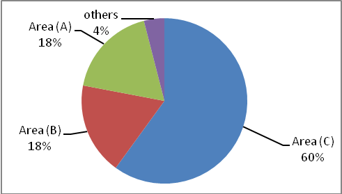
The Israeli occupation used the land classification according to the Oslo Accords (A, B and C) to tighten control of the Palestinian land, especially in areas classified as (C) which are under full control of the Israeli occupation in terms of security, planning and construction, where 76% the of the total area classified (C) is directly exploited by the Israeli occupation; settlements regional councils control 63% of it. While the area of authority regions in the Israeli settlements in the West Bank (Including closed regions and allocated for expanding those settlements) is about 542 km2 as it is by the end of 2019; representing about 10% of the total area of the West Bank. Whereas the confiscated areas for the purposes of military bases and military training locations represent about 18% of the West Bank area, in addition to the Annexation and Expansion Wall that has isolated more than 10% of the area of the West Bank. Consequently, over 219 Palestinian localities were badly affected by the establishment of the Annexation and Expansion Wall. Moreover, data indicates that there are about 2,700 establishments isolated between the Wall and the Green Line, and about 5,300 establishments damaged by the Wall, in addition to 35 thousand households that were also badly affected by the establishment of the Wall. Nevertheless, there are about 67 thousand Palestinians living in isolated buildings between the Wall and the Green Line. Also, the Israeli occupation imposes all kinds of obstacles to tighten their lives and make it almost impossible for the Palestinians urban expansion, especially in Jerusalem and areas classified as (C) in the West Bank and that are still under full control of the Israeli occupation.
Percentage Distribution of Lands in the West Bank According to Oslo Accords
Israeli Settlements: Continuous Expansion
By the end of 2018, there were 448 Israeli occupation sites and military bases in the West Bank including 150 settlements and 26 inhabited outposts that were considered as neighborhood following established settlements, in addition to 128 settlement outposts. As for the number of settlers in the West Bank, it reached 671,007 settlers by the end of 2018; at a growth rate of almost 2.7%. Attracting Jews from abroad represents more than the third of net population growth rate in Israel. Thus, data shows that around 47% of settlers live in Jerusalem governorate, where their number reached about 311,462 settlers; out of which 228,614 settlers live in East Jerusalem (J1) “includes those parts of Jerusalem which were annexed by Israeli occupation in 1967”. In regards to demographics, the proportion of settlers to Palestinian population in the West Bank is about 23 settlers per 100 Palestinians, and it was the highest in Jerusalem governorate, where there were 70 settlers per 100 Palestinians. Accordingly, 2019 witnessed a significant increase in the pace of construction and expansion of the Israeli settlements in the West Bank, where the Israeli occupation approved the construction of 8,457 new settlement housing units. It also approved the establishment of 13 new settlement outposts.
Motivations and Facilitations for Settlers
Annual report data of the Colonization and Wall Resistance Commission indicates that the total expenditure on settlement activities during the period 2011 – 2016 reached one billion NIS, while the total expenditure in 2017 reached 1.7 billion NIS. Also, 1.4 billion NIS were spent in 2018. Moreover, data from the Israeli organization, Peace Now, indicates, in terms of the establishment of settlement outposts, that this phenomenon has mainly started during Netanyahu's era as a Prime Minister in 1996, and it stopped in 2005. It is noticed that the government of Netanyahu went back, once again, to establish illegal settlement outposts; where out of 134 sites that were built: two settlement sites were evacuated (Migron and Amuna); and 29 settlement locations were approved (three as independent settlements and 26 as "neighborhoods" for established settlements); and over 35 sites under approval.
Jerusalem: Intensive Judaization with no controls and continuous demolitions
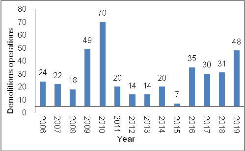
During 2019, the Israeli occupation demolished 678 Palestinian buildings; around 40% of which were in Jerusalem governorate (268 demolishing operations). The demolished buildings were divided into the following: 251 residential buildings and 427 establishments. Also in 2019, the Israeli occupation issued orders to stop the construction of and demolish 556 buildings in the West Bank and Jerusalem. Hence, the Israeli occupation forces continue to demolish Palestinian houses and put obstacles and impediments to the issuance of building licenses. According to the Al-Maqdese for Society Development and Abdullah Hourani Center for Studies and Documentation, about 2,130 buildings were demolished in East Jerusalem J1 during 2000–2019. Also, it demolished about 50 thousand residential units entirely and over 100 thousand residences partially in the Palestinian territories since 1967. Moreover, data from the United Nations Office for the Coordination of Humanitarian Affairs indicated that around 110 thousand Palestinians suffer from internal displacement around the occupied Palestinian Territories during the last decade. Accordingly, the majority of those were forcibly displaced during the conflict that erupted in 2014 in Gaza Strip. Yet, 7,400 of them are still displaced until this moment. In the West Bank, 900 Palestinians were displaced during 2019 after their houses were demolished or confiscated, especially in area (C) and East Jerusalem because they lack the building licenses that are issued by the Israeli authorities. Such licenses are considered something impossible to obtain by the Palestinians. Moreover, data shows that there is an increase in the pace of self-demolition of the houses since 2006 and afterwards, where the occupation authorities forced more than 400 citizens to demolish their houses by their own hands. Also, the year 2010 has witnessed the highest rate of self-demolitions, which reached 70 demolitions, 49 self-demolitions in 2009 and 48 documented self-demolitions in 2019. According to Al-Maqdese for Society Development and Abdullah Hourani Center for Studies and Documentation, there are many self-demolitions that people preferred to keep silent about and they didn't report to the media nor the human rights institutions or civil society institutions. Furthermore, the Palestinians constitute 30% of the population in Jerusalem but they pay 40% of the total value taxes that the occupation municipality collects; however, the municipality only spends 8% of those taxes on the services provided to the Palestinians.
Self-Demolitions 2006 - 2019
The Human Rights Watch estimates that there are 90 thousand Palestinians, in East Jerusalem, currently living in buildings with notice of demolition. It is worth mentioning that the Israeli housing policies in East Jerusalem is discriminate racially against Palestinians, where it allocated only 12% for the Palestinian establishments, whereas it allocated 35% of East Jerusalem lands to building Israeli settlements. Even in this small area, the Palestinians cannot afford the costs to issue building licenses, which is a very complicated and expensive process.
A racist discrimination policy for the use of streets cost the Palestinians more than USD 400 million
The Israeli checkpoints divided the West Bank into more than 100 cantons that prevent the communications between the Palestinians geographic components in the West Bank through the existence of 165 iron gates at the entrance of the cities and villages, as well as 600 military checkpoints for facilitating the process of isolation and separation of Palestinian localities from one another. Also, the Israeli occupation restricts the movement of the Palestinians in some roads that the occupation allocated for settlers, where the length of the roads that Palestinians are deprived from using reaches 40 km; 7 km in Hebron city, in addition to 20 km where partial restrictions are imposed on the use of such roads by the Palestinians. A study by the Applied Research Institute – Jerusalem / Society (ARIJ) indicated that Palestinians lose around 60 million working hours per year due to the Israeli checkpoints and the restrictions on movement, where is the total losses reached USD 270 million as well as the additional use of fuel that is about 80 million liters per year at a cost of USD 135 million.
Continuous Siege on Gaza Strip
Despite the small area of Gaza Strip, the Israeli occupation set up a buffer zone over the Eastern border of Gaza Strip with a width of more than 1,500 m. By that, the Israeli occupation controls about 24% of total area of Gaza Strip that is 365 km2 which is considered the most densely populated area in the world with about 5,533 Person/ km2, compared to 534 Person/ km2in the West Bank at the end of 2019.
Israeli Violations against the Palestinians
The number of Palestinian and Arab martyrs killed since the Nakba in 1948 and until this day (inside and outside Palestine) reached about 100 thousand martyrs[1]. Moreover, the number of martyrs killed in Al-Aqsa Intifada between September 29th 2000 until December 31st 2019 was 10,926. It is said that the bloodiest year was 2014 with 2,240 Palestinian martyrs, 2,181 of them were from Gaza Strip during the war on Gaza. During 2019, the number of Palestinian martyrs reached 151, 29 of whom were children and 9 women. While the number of the wounded Palestinians during the year 2019 reached about 8 thousand persons. By the end of 2019, there were five thousand Palestinian detainees in the Israeli occupation prisons, 200 of them are children and 42 women. In regards to the number of detention cases during the year 2019, it amounted to be about 5,500 cases, including 889 children and 128 women. Furthermore, the occupation authorities continued to issue the order of administrative detention against the Palestinians. In 2019, the number of administrative detention orders reached 1,035, 4 of which were against children and another 4 against women.
Trump's Plan (the Evaporation of the Two-States solution)
The plan suggests to extort about 1,860 km2, which is about 30% of the West Bank lands, and then to annex them to Israel; about 23 km2 is classified as area (B). Also, the number of the Palestinian localities that will be isolated in the area is 178 population localities, where about 330 thousand Palestinians live in and distributed on 33 localities in the area classified as (B) and its population is about 103 thousand persons; 52 localities in areas classified as (C) and its population is around 16 thousand persons; 20 localities in Eastern Jerusalem, where the population reached about 220 thousand persons; and 73 Bedouin localities. The plan also proposes the annexation of all Israeli settlements to Israel, with keeping 15 Israeli Settlement Enclaves in the State of Palestine territories, which means that those 15 settlements will continue to expand in order to form a geographic connection between them as they continue cutting the ties of the remaining geographic lands for the Palestinians on what is left of the West Bank. Furthermore, the plan defines the swap of 833 km2 from the occupied territories in 1948 (equals 13.5% of the total area of the West Bank), where these areas are distributed as follows: the plan suggests the annexation of about 180 km2 from the lands of Naqab Desert to the South of the West Bank; these areas, according to the aerial photos, this region is a desert of steep rocky hillside, in which no source of water is available and without any development value. Additionally, the plan provided an additional proposal according to which about 290 km2 are exploited and used as an industrial area for advanced technology, and 230 km2 from Naqab Desert to be used in farming and for residence, which is located along the line borders that separate the Egyptian Sinai from the Palestinian Naqab. It is worth mentioning that this area is also full of steep rocky hills with no available water sources and it is not suitable for the implementation of such proposals as shown by the aerial photos.
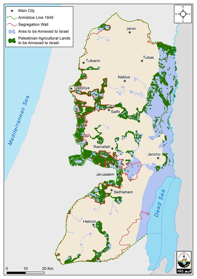
The plan also suggests to make an amendment on the borders of the Armistice line for 1948 in order to amend the border tracks to include more than 10 Palestinian localities at the west of the Armistice line, in which 300 thousand Palestinians reside and live in Al-Muthalath and the area near the borderline of the Armistice line in the surrounding of Kafr Qasem. Furthermore, the plan suggests extorting about 340 km2 from the agricultural lands in the West Bank and annex those lands to Israel "about 89 km2 of those agricultural lands that are located in the area of the Jordan Valley".
Sources:
1. Palestinian Central Bureau of Statistics 2019: Israeli Settlements in the West Bank, 2018. Ramallah- Palestine.
2. Colonization and Wall Resistance Commission 2020: Summary of the most Important Violations in Palestine, 2019. Ramallah- Palestine.
3. The Commission of Detainees Affairs, 2020.
4. Abdullah Hourani Center for Studies and Documentation, the Harvest of the Israeli Violations for the year 2019. Ramallah 2020.
5. The Applied Research Institute – Jerusalem / Society (ARIJ), 2020.
6. Peace Now Organization, 2020.
7. Human Rights Watch. 2020.
8. UN Office for the Coordination of the Humanitarian Affairs in the occupied Territories (OCHA), 2020.